

Tuesday, October 20, 2020
No Result
View All Result
CRETech IoT NYC
Advertisement
  • Home
  • IoT
    • Sensors and Devices
    • Security
    • Building Automation
      • Predictive Maintenance
    • Wireless IoT
  • CRETech NYC
    • News and Events
  • Architectural Design
    • Building Design
      • Access Control & Surveillance
      • Audio Visual
      • Cabling Infrastructure
      • Command Centers
      • In Building Cellular
      • Power Over Ethernet POE
        • POE Lighting
        • POE Security
      • Unified Communication
      • Wireless Networks
  • Green Buildings
    • Sustainable Architecture
    • Green Certifications
    • Energy Optimization
    • Wellness
  • Connectivity
    • 5G
    • Fiber Connectivity
    • Outside Plant OSP
  • Blockchain IoT
    • Commercial Real Estate Blockchain
  • Relocation & Leases
    • Technology Relocation
  • White Papers
    • Smart Buildings
    • Smart Cities
  • Home
  • IoT
    • Sensors and Devices
    • Security
    • Building Automation
      • Predictive Maintenance
    • Wireless IoT
  • CRETech NYC
    • News and Events
  • Architectural Design
    • Building Design
      • Access Control & Surveillance
      • Audio Visual
      • Cabling Infrastructure
      • Command Centers
      • In Building Cellular
      • Power Over Ethernet POE
        • POE Lighting
        • POE Security
      • Unified Communication
      • Wireless Networks
  • Green Buildings
    • Sustainable Architecture
    • Green Certifications
    • Energy Optimization
    • Wellness
  • Connectivity
    • 5G
    • Fiber Connectivity
    • Outside Plant OSP
  • Blockchain IoT
    • Commercial Real Estate Blockchain
  • Relocation & Leases
    • Technology Relocation
  • White Papers
    • Smart Buildings
    • Smart Cities
No Result
View All Result
CRETech IoT NYC
No Result
View All Result
Home Commercial Architecture

11 Steps to Achieve Quality Public Spaces at a Neighborhood Level: UN-Habitat’s Guideline

September 23, 2020
in Commercial Architecture
0
11 Steps to Achieve Quality Public Spaces at a Neighborhood Level: UN-Habitat’s Guideline

11 Steps to Achieve Quality Public Spaces at a Neighborhood Level: UN-Habitat’s Guideline

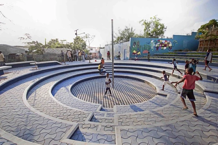
Tapis Rouge public space in an informal neighborhood in Haiti / Emergent Vernacular Architecture (EVA Studio). Image © Gianluca Stefani

Share
Share

Related articles

961 House / Anonym | ArchDaily

961 House / Anonym | ArchDaily

October 20, 2020
Cais do Tojo Building / LADO Arquitectura e Design

Cais do Tojo Building / LADO Arquitectura e Design

October 20, 2020
  • Facebook

  • Twitter

  • Pinterest

  • Whatsapp

  • Mail

Or

The Un-Habitat or the United Nations agency for human settlements and sustainable urban development, whose primary focus is to deal with the challenges of rapid urbanization, has been developing innovative approaches in the urban design field, centered on the active participation of the community. ArchDaily has teamed up with UN-Habitat to bring you weekly news, article, and interviews that highlight this work, with content straight from the source, developed by our editors.

“People all over the world are increasingly demanding a say in the way that their cities are planned and designed”.For our third collaboration, discover UN-HABITAT’s guideline on achieving quality public spaces, a site-specific assessment consisting of a series of activities and tools that help understand the quality of the selected area and plan future design and planning solutions on the site through participatory approaches. Focusing on open public space, within a five minutes walking distance, the guide helps users gather and analyze information, creating a logical transition from needs to design.
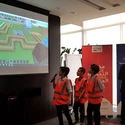
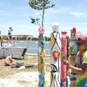
Sharjah, UAE. Image Courtesy of UN-HabitatVietnam. Image Courtesy of UN-HabitatTripoli, Lebanon. Image Courtesy of UN-HabitatNiger. Image Courtesy of UN-Habitat11 Steps to Achieve Quality Public Spaces at a Neighborhood Level: UN-Habitat's Guideline 1+ 14

The Global Public Space Program, launched by UN-Habitat in 2012, aims to promote public spaces or “places that are publicly owned or of public use, accessible and enjoyable by all for free and without a profit motive”, to ensure a sustainable living for all. Throughout the years, drawing upon the experiences in 75 cities, this program developed “an iterative approach to public space” resulting in the creation of the Public Space Site-specific Assessment, a tool to help achieve the five dimensions of good quality public space: safety, inclusivity, connectivity, accessibility, and sustainability.

Shortening the gap between needs and design, this guideline is based on the active participation of community members, technical experts, and the local authorities in each of the listed activities. While it is often considered costly and time consuming for a city to dispatch staff to do surveys, the Assessment offers a range of activities that are affordable and cost-effective.

Tripoli, Lebanon. Image Courtesy of UN-Habitat

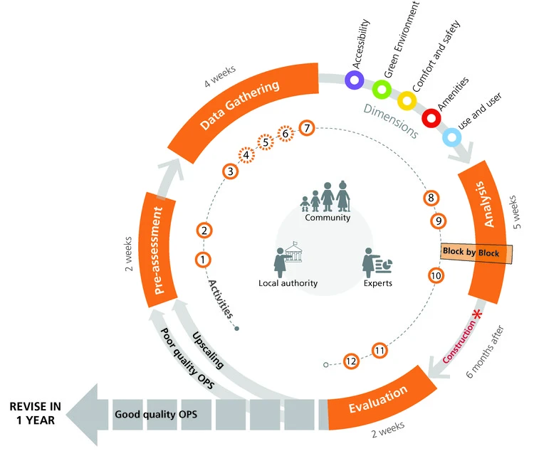
Creating and promoting streets and public spaces, especially for the most vulnerable, the Public Space Site-specific Assessment “goes through four phases and guides the user to measure the quality of public spaces by assessing five dimensions and 20 indicators”. In fact, these indicators can be prioritized depending on the local context, and tailored to the objective of the assessment (improving current conditions or creating a new space). A valuable resource to assess and plan, observable and measurable indicators are classified into five key dimensions that guide the user on how to turn selected sites into more safe, inclusive, accessible, and green public spaces. Read on to discover the four phases: Pre-assessment, Data gathering, Analysis, Impact and evaluation, and their different activities.
Courtesy of UN-Habitat

Pre-assessment

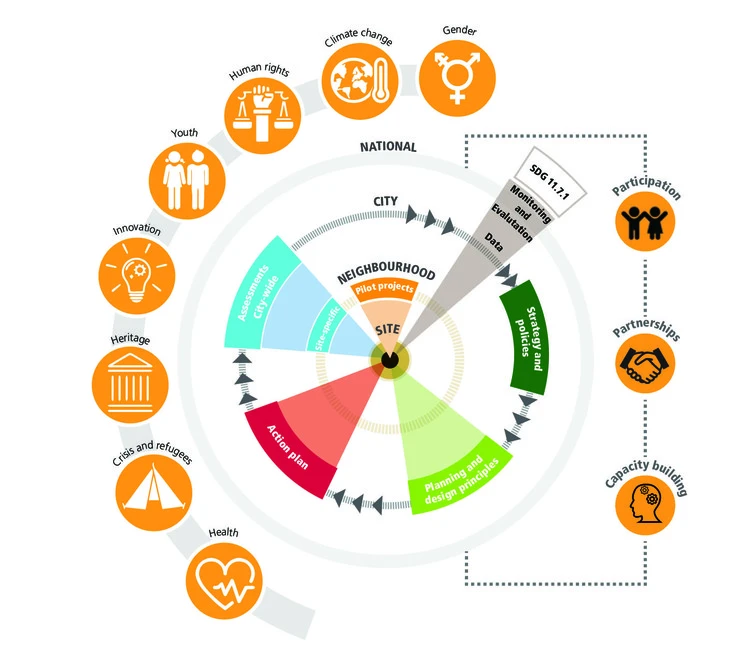
The pre-assessment exercise provides the user with the initial information to get started as an overview of the context as well as information about the demography, history, culture, infrastructure, and the social dynamics of the study area.

  • Project preparation: Organize and prepare the project timeline by mapping key stakeholders and identifying a participation strategy. Understand the city’s priorities, available time, budget, and the local capacities in place.
  • Desk Research: Capture general information, existing studies and highlighting missing or outdated data
Courtesy of UN-Habitat

Data gathering

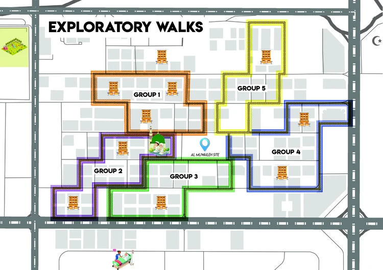
This exercise is structured in a way to get the most information about the five dimensions of good quality public space. While some tools are digital, others adopt traditional approaches that facilitate the collection of both quantitative and qualitative data. In this phase, the level of civic engagement is the highest which gives the community an opportunity to be part of the assessment while also expressing their spatial perception and needs.

  • Observation: Analyze daily life and get an understanding of users’ activities and behavior. Make sure to capture insights as well as data concerning what is happening in the site and around it.
  • Digital survey: Get statistical information from and by the community about their perception and opinion of the public space and its walkable radius.
  • Interviews: Gather data about specific aspects of the site that require specific expertise or knowledge from selected people.
  • Exploratory walks: Experience public space through the eyes of daily users by walking and exploring the neighborhood together.
  • Focus group discussion: Gather people’s opinions and ideas on how they perceive the public space and collaboratively map challenges and opportunities.
Courtesy of UN-Habitat
Sharjah, UAE. Image Courtesy of SUPC

Analysis

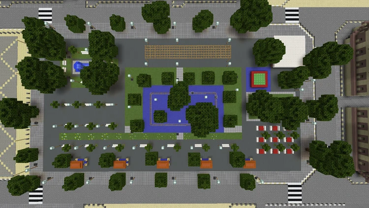
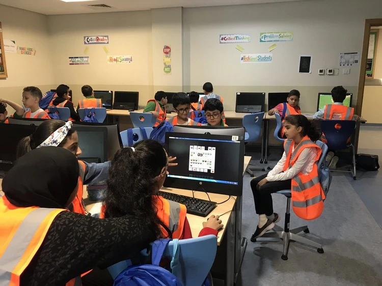
During the third phase, the collected data is cleaned and analyzed to highlight the main issues related to public space and its walkable radius. The technical team maps the findings and underlines the main challenges and opportunities of each dimension. In this phase, UN-Habitat introduces two participatory design activities —The Block by Block methodology, using the video-game Minecraft to co-design the public space with and by the community in a 3D model, and the Expert Design Studio — to ensure community’s needs are incorporated into the final proposal.

  • Findings maps: Curate gathered data and interpret them into five spatial maps that highlight the key findings of each of the five dimensions.
  • Quality scoring: Evaluate the quality of the public space by scoring the five dimensions and their indicators.
  • Recommendations: Produce a suitability map and come up with a list of recommendations and actions to upgrade the public space and its walkable radius.
Sharjah, UAE. Image Courtesy of UN-Habitat
Courtesy of UN-Habitat

Impact and evaluation

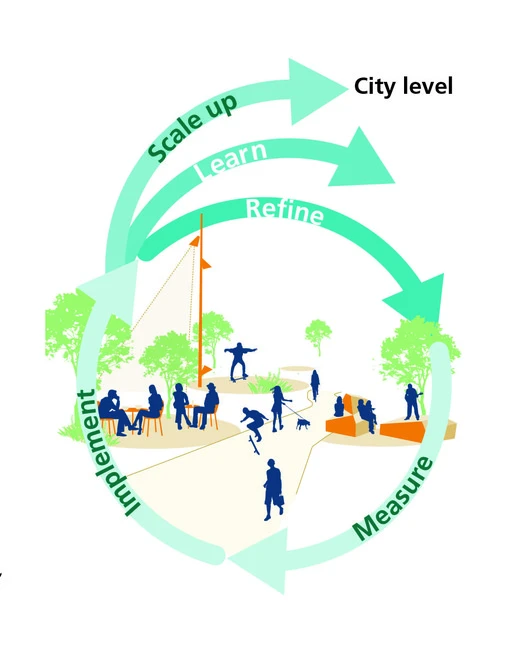
This phase proposes to evaluate the public space after implementation to understand its impact on the neighborhood. It is important to revisit the site one year after construction and evaluate whether the public space met its ultimate goals and objectives.

  • Comparative findings: Measure impact and re-assess the quality of the public space one year after its implementation. Refine, scale-up, and extract lessons learned.
Courtesy of UN-Habitat

Info .


Credit: http://feedproxy.google.com/~r/ArchDaily/~3/vPa8CaDujiw/11-steps-to-achieve-quality-public-spaces-at-a-neighborhood-level-un-habitats-guideline


SendShare19Send

Related Posts

961 House / Anonym | ArchDaily

961 House / Anonym | ArchDaily

October 20, 2020
0

© DOF Sky|Ground+ 14 Share ShareFacebookTwitterPinterestWhatsappMailOrhttps://www.archdaily.com/949863/961-house-anonym Area Area of this architecture project Area:  150 m² Year Completion year of this...

Cais do Tojo Building / LADO Arquitectura e Design

Cais do Tojo Building / LADO Arquitectura e Design

October 20, 2020
0

Cais do Tojo Building / LADO Arquitectura e Design © Francisco Nogueira Architectural Photography+ 28 Share ShareFacebookTwitterPinterestWhatsappMailOrhttps://www.archdaily.com/949693/cais-do-tojo-building-lado-arquitectura-e-design © Francisco Nogueira...

Leave a Reply Cancel reply

Your email address will not be published. Required fields are marked *

Stay Connected

  • Trending
  • Comments
  • Latest
eufyCam 2C vs Blink XT2 Compared – Which is the best budget wire-free security camera?

eufyCam 2C vs Blink XT2 Compared – Which is the best budget wire-free security camera?

March 17, 2020
The 100 Most Sustainably Managed Companies in the World

The 100 Most Sustainably Managed Companies in the World

October 15, 2020
Inside the World of Private Jet and Yacht Interior Design

Inside the World of Private Jet and Yacht Interior Design

April 16, 2019
The Leading Industry 4.0 Companies 2019

The Leading Industry 4.0 Companies 2019

January 23, 2019
Why Smart Buildings of the Future Need Autonomous Cleaning

Why Smart Buildings of the Future Need Autonomous Cleaning

0
PG&E Faces Serious Financial Risk From Devastating California Wildfires

PG&E Faces Serious Financial Risk From Devastating California Wildfires

0
UC Santa Cruz Signs 2-MW Solar Parking Canopy Deal with ForeFront Power

UC Santa Cruz Signs 2-MW Solar Parking Canopy Deal with ForeFront Power

0
Shell Energy Inside Smart Buildings Solution

Shell Energy Inside Smart Buildings Solution

0
961 House / Anonym | ArchDaily

961 House / Anonym | ArchDaily

October 20, 2020
Focus on IOT

Is Your Home Causing You to be Moody? Paint Your Home with these Colors Instead | iotosphere

October 20, 2020
Adtech Company Adwerx Moves to Flexible Work Arrangement

Adtech Company Adwerx Moves to Flexible Work Arrangement

October 20, 2020
Cais do Tojo Building / LADO Arquitectura e Design

Cais do Tojo Building / LADO Arquitectura e Design

October 20, 2020
CRETech IoT NYC

CRETechIoTNYC.com is a Breaking News Portal Addressing Technology Innovation within the NYC Commercial Real Estate Market.

Topics

  • CRETech NYC
  • Architectural Design
  • Connectivity
  • Relocation and Leases
  • White Papers

  • About
  • Privacy Policy
  • Contact Us

© 2018 cretechiotnyc by Designing Smarter Buildings Since 1979.

No Result
View All Result
  • Home
  • IoT
    • Sensors and Devices
    • Security
    • Building Automation
      • Predictive Maintenance
    • Wireless IoT
  • CRETech NYC
    • News and Events
  • Architectural Design
    • Building Design
      • Access Control & Surveillance
      • Audio Visual
      • Cabling Infrastructure
      • Command Centers
      • In Building Cellular
      • Power Over Ethernet POE
      • Unified Communication
      • Wireless Networks
  • Green Buildings
    • Sustainable Architecture
    • Green Certifications
    • Energy Optimization
    • Wellness
  • Connectivity
    • 5G
    • Fiber Connectivity
    • Outside Plant OSP
  • Blockchain IoT
    • Commercial Real Estate Blockchain
  • Relocation & Leases
    • Technology Relocation
  • White Papers
    • Smart Buildings
    • Smart Cities

© 2018 cretechiotnyc by Designing Smarter Buildings Since 1979.

\r\nCredit: http://feedproxy.google.com/~r/ArchDaily/~3/vPa8CaDujiw/11-steps-to-achieve-quality-public-spaces-at-a-neighborhood-level-un-habitats-guideline ", "author": {"@type": "Person", "name": "cretkatm", "url": "/author/cretkatm/"}, "articleSection": ["Commercial Architecture"], "image": {"@type": "ImageObject", "url": "/wp-content/uploads/2020/09/Gianluca_Stefani_-_rule1.jpg", "width": 1500, "height": 1000}, "publisher": {"@type": "Organization", "name": "", "url": "", "logo": {"@type": "ImageObject", "url": ""}, "sameAs": ["#", "https://twitter.com/cre_ot", "https://www.linkedin.com/in/cretech-iot-nyc-0533ab175", "#"]}}